|
|
| Svalbard | |
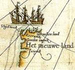
Polar map 1599 |
The name Svalbard is known since the middle ages. It is mentioned in the Landnámabok in the 13th century, but we don't know for sure if that is the same islands as is known under the name Svalbard today.
Willem Barentsz didn't know the island when he discovered and named Spitsbergen i 1596. On his map from 1599, we find the islands for the first time, called "the New Land". |
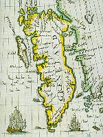
Map form 1624 |
During the 17th century, hunting and whaling developed in the Svalbard region. This activity characterizes the map by Samuel Purchas from 1624 (290x330), where Spitsbergen is called Greneland. |
Spitzbergen. 1839 |
The La Recherche Expedition 1838-89 spent a long time on Spitsbergen conducting scientific research. |
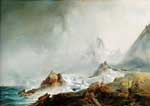
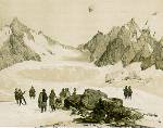
From Spitsbergen |
The painter, Wilhelm Schiertz, participated on the Norwegian 1876-1878 Northern Seas Expedition. This image depicts the so-called "Norskøyene" (Norwegian Islands). |
|
|
|
© University Library of Tromsø - 1999.
The Northern Lights Route is part of The Council of Europe Cultural Routes. The Cultural Routes are an invitation to Europeans to wander the paths and explore the places where the unity and diversity of our European identity were forged.
|

|