
|
|
June 12th 1596 
August 28th 1596 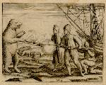
September 15th 1596 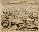
June 20th 1597 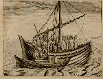
August 16th 1597 |
Willem Barentsz and the Northeast passage
During the second-half of the 16th-century, both Englishmen and the Dutch attempted to find a northeastern trading route to China by way of the sea. The first unsucessful attempt to reach this goal was undertaken in 1553, on the initiative of London's newly established Muscovite Trading Company. Up to approximately 1580, after several attempts, the English withdrew and the Dutch started their own efforts. England, on the other hand, established brisk trading with northern Russia - trade that also had great significance for the "king's congregation" in the northernmost part of Denmark-Norway. The English never reached further than to Novaya Zemlya, while the Dutch expeditions got as far as the Kara Sea, in the 1500s, before being stopped by the ice. 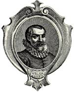 Willem Barents was on such an expedition in 1594. By 1595, the Dutch believed that they had found the Northeast Passage and sent out another expedition with Barents. This expedition consisted of several ships, heavily loaded with trading goods intended for the Chinese trade. The journey failed however.
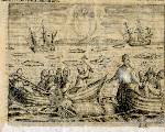
Dutch merchants did not capitulate. Instead, they supplied a new expedition, in 1596, of which Barents followed along as a pilot. It was this expedition that reached Svalbard in June of the same year. After having been on land at Spitzbergen, the expedition then continued on until the ship got locked in ice, and sank, to the east of Novaya Zemlya. The expedition members had to stay on through the winter and, in the following year, they headed southwards on two open boats. Willem Barents died on this journey, while the surviving expedition members managed to reach the Kola Peninsula after experiencing severe hardships. There they met a Dutch vessel that led them home to the Netherlands. Willem Barents conducted geographical measurements during the initial voyage and, in 1599, a map was printed showing the polar regions that are named after him. Two of the members of these three expeditions have written memoars. Jan Huyghens van Linschoten participated on the first two voyages, while Gerrit de Veer joined the final two expeditions. Gerrit de Veer's book is written like a diary. Both books, however, are richly illustrated; van Linschoten, for instance, has maps and topographical plates that show the first easy-to-recognize depictions of the North Cape and Vardø.
|

|
© University Library of Tromsø - 1999.
The Northern Lights Route is part of The Council of Europe Cultural Routes. The Cultural Routes are an invitation to Europeans to wander the paths and explore the places where the unity and diversity of our European identity were forged.
|

|